
The Cuningar Stones: The Map Stone
By James Winnett
2014 - 2016
- Sculpture
- Urban Dynamics & Public Realm
- Participatory & Collaborative
- Abstract & Conceptual
- Cuningar Loop
- Forestry Commission
- Glasgow
- Rutherglen
- Stone Carving
- Sandstone
- Ruin
- Gorbals
- Map
- Landfill
- Environment
Dimensions
100 x 65 x 40
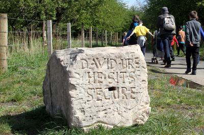
Pale rectangular stone showing a map of the Cuningar Loop on the upper surface. The course of the river is carved deep into the stone with a bridge linking the two banks. A series of carved pictorial motifs appear across the stone, intersected by a network of pathways.
The Cuningar Stones is a permanent public art project for the Cuningar Loop Woodland Park, a 15 hectare former landfill site in South Lanarkshire between Rutherglen and Dalmarnock. As part of the project 15 large carved sculptural works were produced drawing on an extensive programme of research and community engagement which examined the complex social, industrial and natural history of the site.
Each stone was recovered from the ground after being dumped there during the demolition of the Gorbals in the 1960s. Developed to reference Scottish folk carving while retaining the aesthetic of an architectural ruin, the stones act as landmarks within the landscape encouraging exploration and generating interest in the identity of the park. Each stone retains the architectural details and other marks from its history with my own carvings intervening in these layers. Many of the carvings reference the rich flora and fauna of the park.
The content of the carvings was developed through the supporting engagement programme involving adult and children's stone carving, mask-making and design workshops, audio history recordings, exhibitions, talks and events. This self-led project was supported by Creative Scotland with National Lottery Funding.
For further information on the project see: www.cuningarloop.tumblr.com


Join Axis
We support artists
Funding, visibility, connection and practical help.
Membership includes £15 million of Public Liability Insurance!